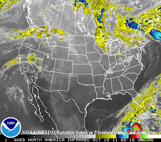
This map was taken from a NOAA satellite and it shows a recent image of the United States. The image is taken in the infrared band light span to show heat within objects. Color demonstrate the variety between the cooler and warmer objects, colder are brighter while warmer are darker. Altitude also has an affect in this image because clouds closer to the continental surface tend to have warmer temperatures, these are depicted by the color gray. Colder clouds, which are generally formed at higher altitudes are highlighted in color because the purpose and focus behind this federal institution is to alert people of possible weather hazards. These clouds are more likely to become a supercell, which provides stronger storms with higher intensity winds, rain, thunder, and possibly produce tornadoes. The infrared system is useful for both day and night since it detects the image based on temperature differences.
The above image shows water vapor in the atmosphere. I have decided to include both these pictures to contrast the difference in the changes of temperatures as compared to atmospheric moisture, during the same period of time. Instead of an infrared satellite picture, this image was taken using a wavelength sensitive to the density of water vapor in the atmosphere. Once again, color and brightness is used to indicate high water vapor, while colored and white areas include high moisture and, or ice crystals-which once again, are more intense, and hazardous weather conditions. Black and brown areas have little to no moisture. This can be areas where there is a drought. It is importance to notice that conditions for La Niña have been detected, which might be affecting the weather system, and this map. These conditions may intensify with time. Wavelength imagery is useful for moisture and atmospheric circulation indicators, as opposed to infrared which is better for determining temperature.

No comments:
Post a Comment