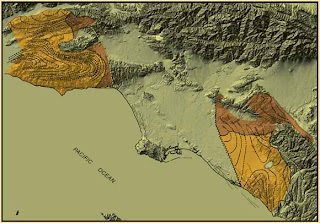
An Isopach map illustrates the thickness variation within a tabular unit, like other map types, Isopachs have contour lines of similar thickness over an area. They are extremely useful for geologists and geographers because they are used for hydrographic surveys, sedimentology, volcanology, etc. This map is from 2004 Los Angeles Basin, California. The mapped margins are of depositional basins of the Sespe-Vaqueros Formations on a shaded elevation map in the area of study.
No comments:
Post a Comment